

This hike was initially planned for October 1994, when I was still living in the Free State. After I have done two extended hikes in the Cederberg in the late 1980’s, I asked a Mountain Club old-timer from Cape Town, Colin Inglis, to help me plan a nice hike through the southern Cederberg and the Breekkrans area (a large piece of land owned by the MCSA since 1983). Colin (who passed away in 2005) was a distinguished MCSA leader, a very nice person, enthusiastic, friendly and a true gentleman. He was familiar with the area and mailed me a map copy with a proposed 5-day hiking route drawn on it with an orange Koki pen. It looked like a great hike and I put it on the Free State Section’s hiking program. But there was not enough interest that year, and I had to cancel it. I tried again a few years later, but it didn’t materialize.
I kept the map, and when I discovered it again two years ago, I decided to do this hike while I am still alive. One thing that bothered me a bit, was that the paths of the early 1990’s might not be there anymore…. The latest Slingsby map of the area still indicate paths along certain parts of the route, but there were also a few question marks printed along these paths. However, I was sure that a group of tough MCSA hikers would be able to cope with a route like this.
And so, on the afternoon of 24 October, 16 enthusiastic hikers gathered at the Kromrivier camping ground. Some of us did the braai thing, most drank some wine and all of us worried about the weight of our packs, having to carry 5 days’ supplies ànd a tent. Some of us ended up with more than 20 kg on the back…
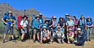
The group: (standing) Fanie Potgieter, Gillian Forbes, Johan Huisamen, Hugh Sussens, Annalet Donald, Amelia Spargo, Liza Serfontein, Clifton Donald, Dennis Lange, Jacomi Odendaal, Derek Odendaal, Ed Kay-Shuttleworth. Kneeling: Carine Gagiano, Jacolise Joubert, Sonja Wend, Mimmie Kay-Shuttleworth.
The next morning we were off, struggling to get used to the weight on our backs. But the scenery and the prospect of adventure kept us positive. We walked up the Kromrivier valley along a well-used path, past the beautiful Disa Pool. The first day was rather easy and we pitched tents at about 2 pm, next to a stream. A few energetic hikers even walked to the Maltese Cross and back. I must add that there were quite a few “energetic hikers” in the group (I call them “haastige honde”), and then also a few leisurely hikers, wanting to stop for photos, admiring the flowers, conserving energy, etc. Such a mix is obviously difficult for a leader to manage.


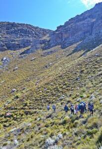
The second day we walked further up the valley, past Bakleikraal and then onto a traverse to the south along the west-facing slope of the shale band. We had distant views of the Citrusdal area and impressive cliffs to the east. The path was now very faint. Later we turned east again into the upper part of the Beesgat valley, where the paths disappeared. We were now on the Breekkrans property. Gradually the going became rougher, but the scenery was great. We walked on the route of the old Cape wagon trail, which was the access route into the southern parts of the Cederberg in the late 1700’s and early 1800’s. But with no use during the last probably 150 years, this old trail was of no help! After some rough going, we camped at the old Beesgat Campsite next to the stream. The sun was hot and we had very little shelter from it. But we had beautiful cliffs high up on the slopes in all directions, and a variety of fynbos birds entertaining us. We also had good food (but a small ration of wine…)
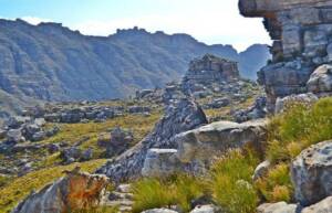
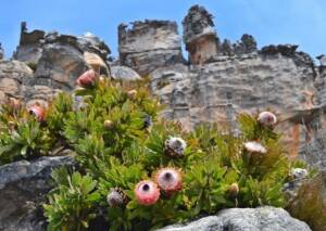
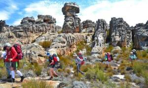
On the third day we went south, up onto the wide ridge and high plateau area, extending from Apex Peak right across to the Sandfontein Peak area. Here the terrain is very broken with the typical Cederberg formations of the higher areas. Navigation became challenging and more energy had to be spent (it is not a flat area!). But this was the area that I wanted to explore for the past 30 years. I was absolutely thrilled to be here (while the rest of the group also loved it!).
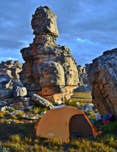
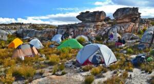
The fascinating rock formations in this area tend to give you a visual overload as you go from rock tower to rock tower, and from weird formations to something even more inspiring for the imagination. The going was not easy and tired us. By mid-afternoon I realised that the day would become extreme if we kept on walking to the planned overnight stop at the Sandfontein Arch. So we rather camped near Hamerkop, at the eastern end of the wide plain. It was actually a stunning setting, with all the rocky hills and towers all around us. And the sunset was exquisite. I now had to adjust our planned route. We had to go down to the north via a different route from the plateau we were on. And a map does not tell you everything…
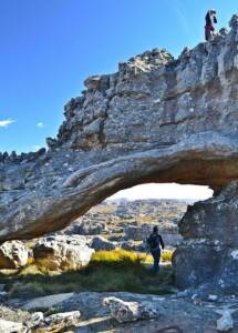
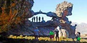
The following morning we went exploring to the east (without our packs), also visiting two of the well-known arches in that area, namely Spinnekop Arch and Vlerkboog. The latter one is definitely stronger than it looks…. Later that morning we shouldered our packs again and had to find a route down into Sandfontein Ravine and then into the Hondverbrand valley. This was challenging terrain and steep down. We were now in a very remote area, and I did not want somebody to get an injury! With the aid of a few eager scouts/route finders, we managed to find a rough and spectacular route down all the way. We then hiked up the Hondverbrand valley through upper Dwarskloof. We had to cover more distance that day and went up a steep slope to the plateau just east of the Breekkrans Twins, where we camped for the night. It was rather windy and we could see from the clouds that our good weather so far was heading for something a bit different.

The fifth and last day presented us with mist and cold air. The biggest navigational challenge of the trip was waiting for me. My route, as indicated by Colin Inglis, showed a very steep descent of some 500 m down into the Breekkrans valley to the North. But the terrain looked impossible with cliffs all around. Through sheer determination, scouting and a bit of luck, we found a route down. It was very rough and somewhat risky. But that is what we Bergbokke do! I prayed everyone down into safety. With some further good fortune, we found the faint old path running down along the valley. It helped a lot, but was very overgrown in places and those with exposed legs had a painful experience. It drizzled from time to time.
At last we reached Kromrivier Park again, just before 2 pm. Nice craft beers and very nice food at their restaurant was a good ending to a fantastic and adventurous hike. Thanks Colin – you surely knew the area, but also realised that I would love an adventure. However, I will have to return to see the Sandfontein Arch…
Meet Leader ~ Derek Odendaal